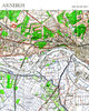
 The original of this map is almost entirely clean, and is a coloured map covering Arnhem, the River Rhine and, importantly, extends westwards to include the DZs and LZs used for the intial airborne assault in Operation Market Garden. Of fundamental importance to all who are interested in this operation. A 1;25,000 scale map it has a great amount of detail. Covers the whole area of the operation in one map.
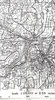
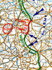 This map shows the relative positions of the BEF, the French, Belgian and German Armies on 15 May 1940, soon after the German assault began. See also the maps for 20 and 26 May and the Dunkirk evacuation area.
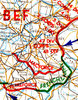 This 1:1,000,000 scale map show the situation of the BEF (British Expeditionary Force) on 20 and 26 May 1940, together with the operational areas of the French, Belgian and German Forces engaged in the fighting. The BEF details include divisional areas.
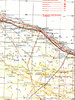
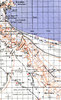
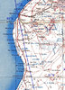 Covers the North African coast from west of Marble Arch (marked) to Torbruch via Bengasi. Shows terrain inland, the coastal road and Msus, Barce, the Gebel el Achdar and Adegabia.
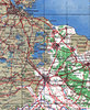
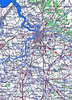 The map covers the area from Antwerp and Brussels in the west to München-Gladbach in the east and is valuable in studying movements and operations in 1940 and 1944/45. (See also Seine-Ameins and Amiens-Brussels)
 The area covered includes the Seine river from its estuary to Paris and extends east as far as Amiens. (See also Amiens-Brussels and Antwerp-Brussels).
 The map covers the Normandy area south to below Falaise, in the west to Omaha Beach area and in the east to Trouville. Shows all locations and the important topography of the inland area.
A general topographical map of Northern France showing the area from Brittany to the east of Paris, and as far south as Nantes and Tours. With scale and main roads and railways.
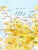
 This map covers the whole area east and west of El Alamein, and southwards to the Qatara Depression. It is perfect for studies of the Battle of El Alamein and other operations in the area. It was published in 1942 and includes going information which was vital to motorised and armoured units. [See also the MLRS reprints of operations in this area in 1942, including Operation Supercharge].
 A 1:100,000 map of the area in western Egypt including Sollum and the Halfaya Pass. Includes going details.
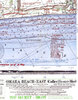 The two maps are of Omaha Beach and cover the whole landing area and show the German obstacles laid to obstruct the landing. Dated to 12 May 1944, and classified as "BIGOT" - the highest security classification.
 Operations Plunder and Varsity were the code words for the Allied crossing of the Rhine - an airborne assault and a close follow-up river crossing, The map shows the operations ane their achievements. Also available: the Battlefield Tour volumes of both operations.
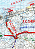 This is a 1:100,000 scale map of the Dunkirk area on 28 May 1940. It shows the perimeter, Corps locations and the harbour and beach areas from which the evacuations in Operation DYNAMO took place.
 A simply stunning map of the Torbruch defences on 12 January 1941, three months before the siege began. Every position is marked together with its composition (weapons etc) and the map also includes administrative and tactical locations and the harbour area.
 This map was issued to troops approaching or in the area of Vire in 1944. It is an emergency black and white printing (done by the Royal Engineers in the field) and shows a detailed picture of the countryside to the North of Vire as well as the town itself. The original map was used in battle.
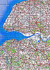
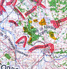
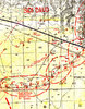
 A good map of the coast and islands of Holland as well as the hinterland. The map also shows the operational area for Operation Market Garden and Walcheren, North Beveland and the port of Amsterdam. A good clean map, used at the time.
MLRS Books provide a download service for military historians and those interested in military history.
We specialise in primary source material and accounts which are assembled from such sources. We also publish new titles of specific interest in the field of military history and military genealogy.
MLRS Books offers a catalogue of resources via download only and
these are not printable. Should you want physical copies of our products, we
recommend visiting Caliver Books.
Payment is via Paypal, and prices are as quoted. Hopefully you will be pleased with your purchase,
however, do e-mail if it isn't and we'll try to fix it.